
 |
| Thanks Pats for this shot. Lovely!^^ |
Major Jumpoff: Sitio San Martin, Subic
LLA: 14°49.03N, 120°06.25E, 450 MASL
Days required / Hours to cove: 1-2 days / 3-4 hours
Specs: Minor climb, Difficulty 3/9, Trail class 1-2
Features: River crossing, beach
I’ve conquered a couple of mountains from the South so why not go up North this time. ^^ My bestfriend and I had plans way back to travel out of town. Good thing our schedule permitted us and one day we found ourselves planning about conquering Nagsasa. I got so excited about the idea of trekking up north again which includes hitting the beach before the summer season ends. Aside from that, a new set of people to meet which thrills me more. This is what I love about travelling; you get to see new and wonderful places, new learning and new found friends.
The group met at Victory Liner, Caloocan around 9PM. At exactly 11:30PM, the bus we boarded left and we're bound for Olongapo. We tried to catch some sleep on our way to Olongapo (which most of them did, except me and Mario. EXCITED MUCH MODE). We arrived at Victory Liner Olongapo at 2:05AM. From there, we had to ride a jeepney going to the jumpoff point (Sitio San Martin, Subic). On our way to San Martin, we had to stop by PNP to secure our permits and pay the registration fee. We reached the jumpoff point at 3:30AM and secured our guides.
 |
| First group pic before starting our trek. Note: Pakiramdaman mode pa kaming lahat |
 |
| Very True! |
The trek started at 4AM, it was slippery and a bit muddy due to the rain showers. That didn’t stop us from this adventure. Wearing our headlights, we started to walk in a very dark trail. Since it was dark, we had to pass messages to one another to make sure that no one would get hurt with rocks or if the path is going left or right. The initial walk was long but since we started long before sunrise, the atmosphere helped to make the walk more relaxing. We also crossed a river. The trail was not steep but it was long. We were so excited to see the sunrise so we stopped for a while to capture that moment.
 |
| First pic that the group was complete. Thanks to Kuya Joseph! pwedeng wede |


 |
| Credit to Pats (ang shot ng tunay na camera) |
 |
| Credits to Pats (ang shot ng tunay na camera) |
 |
| pahinga mode |


Obviously we really enjoyed our rest. We really took time to get our own shots of the lovely view. The wonderful view served as my energy booster so I decided to start the trek again. I can’t wait to see the view from the ridge.
 |
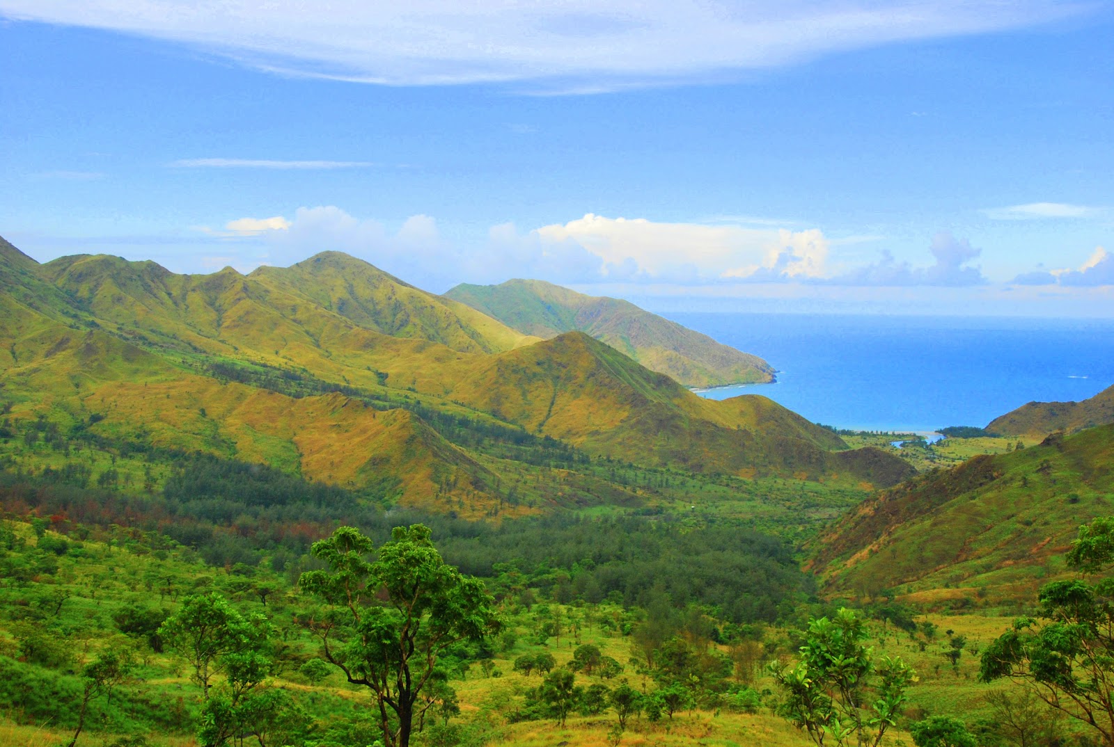
| The view from the ridge |
 |
| yes you got it right. it's a rainbow! |
NOTE: You can actually see 2 other mountains on your way to the ridge (Mt. Balingkilat and Mt. Cinco Picos)
While crossing a steep path:
Me: Kuya! May nalaglag na ba dito?
Guide: Ay ma’am meron na po… pero nakakapit
(may lihim akong ngiti habang tumatakbo sa isipan ko “buti naman”)
Guide: Sa katunayan po dito po nangyari sa kinatatayuan natin ngayon
(OO na! sabi ko na, minsan di nakakatulong ang pagiging matanong ko. Hahaha…)
When we finally passed that path, a breathtaking view caught our attention. We saw the blue waters of the beach. It gave us a super boost of energy and disregarded that we were super wet from head to foot.
 |
| Credits to Pats |
 |
| Ang mga basang sisiw. hahaha... |
 |
| Cresdits to Pats |
After our challenging experience on the ridge, we proceeded with the trek. As per our guide, it’ll be 2 more hours to reach the shore (depending on how fast we can pass the valley).The trail between the saddle and the shore was long. The trail ran through rocks, dry river, streams, soft sand, hard sand, cogon and more sand.

 |
| Credits to Mario (Aran and Me) |
 |
| Credits to Pats |

 |
| Dry River |
 |
| Credits to Mario |
 |
| Credits to Mario |
 |
| Credits to Mario |
A few hours later, we could already see the shore. It was a sight to behold. All the efforts spent trying hard to get to the beach were worth it. Everything was worth it!
We reached the camp site at 10:15AM. The beach and the river were breathtaking. It has soft white-grayish sand (ash-colored) with Agoho trees (resembling to Pine trees) around the place. Although, there was no electricity, no drinking water and no cellular phone signal in the place. It only has a common CR and water pump to share with other visitors of the place.
Though tired and weary, we still managed to set our tents and cook our much awaited Brunch.


The entire time we spent on the beach was dedicated to having as much fun in and out of the water. We swam, had pictorial sessions, walked along the shore, getting-to-know-you time and socialize.


After dinner and short chit chats with them, I felt my eyes were getting heavy. I realized that I haven’t gotten any decent sleep and rest. I ended up, sleeping earlier than they did. I actually lost a lot of juicy topics and discussion whilst I’m sleeping. End of Day 1.
PS. Day 2 will be my next post ^^

16 comments:
I specially love the sunrise photos! Ganda!
Same here... i also love that pic ^^
Amazing scenery!
Have u gone to Anawangin also? the sand in there were kinda disappointing according to my sis. It did not much like before... but Nagsasa is maintained! ganda ng photos!
@bradpetehoops - indeed! thanks for dropping by
@mitch - di pa ako nakakapunta ng anawangin eh pero ive been hearing a lot of comments from people who visited the place and sad to say, it is not as good as before. that's why we decided to visit nagsasa instead.
adventurer ka talaga...natawa ako sa quote....don't change the mountain, let the mountain change you..
hahahaha... adventurer ba? slight lang naman. hihihi
ilang bundok na naakyat ko at ilan sa mga iyon eh may quote na yan
ganda tlaga ng place na yan ... hay ! mapupuntahan ko din yan
tama! ganda talaga... sige go for gold! visit na ^^
Check my Day 2 - andun yung expenses ko for this trip and yung mga contact #s.
check this link: http://iamjessiegarcia.blogspot.com/2012/06/nagsasa-cove-via-mt-nagsasa-day-2-may.html
sureness! my pleasure to help ^^
malaki talaga ang advantage pag malaking grupo coz you can save a lot
The island looks really beautiful, The picture looks really nice as well specially the sunrise, It really beautiful.. I wish I could visit the island one day with my friends.
www.travelvisaaustralia.com
Gaano ka-steep yung steep path?
Hi. Paano po makakuha ng guide at saka paano po yung pagkuha ng permit?
Hi. Paano po makakuha ng guide at saka paano po yung pagkuha ng permit?
Hi Guys,
Sorry for the late response. Sa Jump Off point mismo mag-offer yung barangay officers ng guide. Dun na rin kayo magbabayad. Also please check our Day2 for more info
Post a Comment